Six of the best Car and Motorbike GPS Navigation Apps.
Google Maps has long been a favourite of the community, even before the turn-by-turn navigation function was introduced. Now the global giant has provided arguably the best free navigation software out there. Lets look at some of its features.
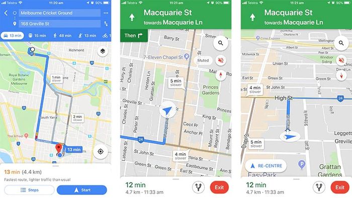
Step by step navigation - Although this is becoming more of a standard these days, the quality of Google Maps’ version is above the rest. Google Maps will give you 3 options to chose from and give detailed (and easy to read/understand) traffic information. Then, using a very human sounding voice it will guide you through the journey. One of the other impressive functions is how quickly it will re-route you if you take a wrong turn, definitely a thumbs up.
Quality Directions - By using up to date traffic info, courteously of the newly acquired ‘Waze’, Google Maps gives three options every time you need to use it for navigation. It also gives you the option to avoid highways and tolls roads.
Personalised features- Signing into google maps with your google account really enhances Google Maps. It allows you to set your home and work addresses as well as favourites and recently travelled locations. I even pulled up a previously travelled location from 2 months ago, without having to type it in again
Public transport - Google Maps offers relatively accurate public transport information, this can be a little bit ‘hit and miss’ from my experience, but I would imagine it will only get better.
Bikes/walking trails - Google Maps has a brilliant coverage of walking and riding trails and takes these into account when navigating a route for you to ride. Fantastic feature.
Easy to read traffic - Although other navigation apps do take traffic into account, none make it as easy to read as google maps, simple colour coding makes it easy to see which will be troubled points of your trip.
In my opinion the only real shortfall of Google Maps is that they don't show fixed traffic cameras, or display your speed as you drive. However, Google Maps is still my tip for anyone looking for a simple and easy navigation app.
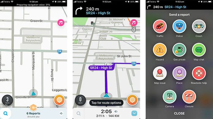
Waze is a community based navigation app. This means that all information that is used is sent in by it’s users. This is done either passively (having Waze open whilst driving) or manually (submitting facts, traffic jams, speed cameras, map editing, etc). This is a revolution in navigation and really works well if the community around you get on Waze as well (they do have over 50 million users world wide). So start the revolution in your area and get reporting today.
Points of interest - People in you community can point out things they like - bars, clubs, restaurants, fast food, malls, hotels, attractions, etc. As well as Petrol/Gas stations, including their prices, making it easier for you to choose where to fill up.
Step by step Navigation - Their step by step is as accurate as google maps, however the rerouting function can also be a little bit slower than that of Google Maps (in my experience) - however it’s still quite quick.
Socially reported aspects - Because users can report things of interest, they can also report things they don’t like as well. These include speed cameras, red light cameras, traffic jams, break downs and other road emergencies. Obviously this is a very handy feature.
Classes - Waze allows you to earn points for driving with the app open, reporting things and making milestones. This moves you up through the ranks - the higher your rank, the more influence you have when reporting things (and obviously you are just generally cooler).
Waze is a really cool app, and if you're like me and find working your way up classes fun, this this app is probably for you. It doesn't do much wrong.
Apple Maps
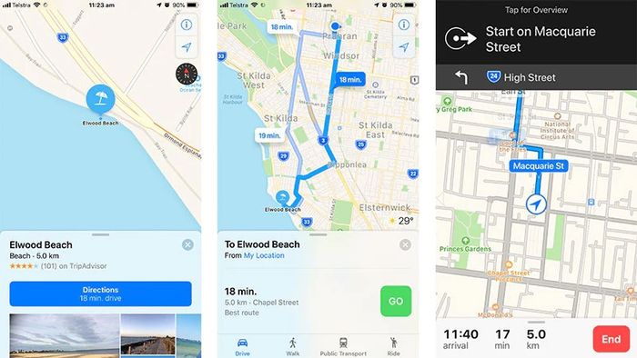
Being an Apple app, obviously the biggest reason to use it would be its integration with the phone itself. From the ability to use Siri to using your contact list to quickly move between locations, the integration is by far the most stand out part of this app.
Contacts integration - As stated in the heading, the ability to save your contacts addresses to get directions easily without any effort is unmatched. This is because Apple do not allow third party apps to integrate, the same way they allow their own.
Siri Integration - Finding and setting directions to other locations is made easy with apple maps and Siri. The same can be said about this as the contact list.
Step by step - Apple Maps does give free turn by turn navigation, however it’s route calculation has been widely criticized, even landing two Australians lost for 2 days in a National Park. It also displays traffic information very poorly, it takes it into account, but doesn’t really allow you to see where the traffic issues are.
Apple Maps has definitely improved since it was first released, but it still doesn't do enough to beat Google Maps or Waze. Unless you spend a lot of time going between clients houses, flicking between the contact list would probably make your life a lot easier.
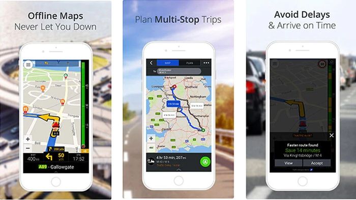
CoPilot offers many of the same features as Apple and Google Maps, however, to use the premium features - such as turn-by-turn navigation, you must buy the premium service for $34.99 AUD.
Layout - I think the CoPilot App has a nice layout to it, quite colourful and informative. However, some may think it is a little bit cluttered.
Downloadable Maps- This is a good and bad feature. For those people who only have a small amount of space on their phone - this is not for you. For anyone else, this is a fantastic feature that cuts down on roaming data usage and enables you to use the app in remote locations, in which you may not be able to get any internet reception.
This is a quality app, but it just doesn't do as much as the others do for free. If downloading the maps is a big thing for you, $34.99 might be worth it.
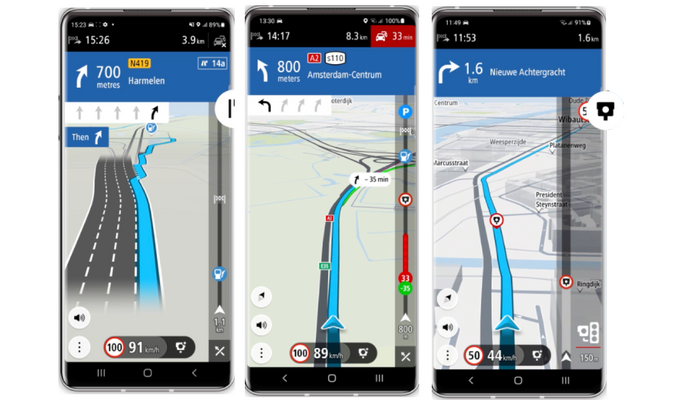
TomTom GO Navigation is a paid premium app for both cars and trucks. It leverages TomTom’s 20+ years of expertise, offering features that enhance your driving experience. Here are some of the features which make using this app a breeze..
Clear lane guidance - This feature is designed to make navigating stressful intersections and junctions a breeze. Just follow the blue line to know which lane to take and never miss an exit again.
Speed camera alerts - Enjoy peace of mind with global coverage of speed alerts for fixed and mobile speed cameras.
Live traffic information - Stay up to date with the latest road conditions through real-time data. Receive alternative routes to avoid traffic jams and road closures, saving you time and money.
RouteBar™ - Know what’s ahead on the road with our trademark RouteBar. It displays points of interest such as gas stations, speed cameras, traffic jams and more along your route.
Complete speed info - Stay in full control of your drive. Get real-time displays of your current speed and speed limits of the road you’re on.
Overall, this app is on the pricier side but the features make it worth the extra dollars. The best navigation app for you will depend on your individual needs and preferences, so if you're looking for an accurate and reliable app with offline maps and voice-guided navigation, then TomTom GO Navigation is a good option.
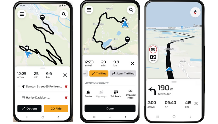
TomTom also has newly introduced the GO Ride app for its motorcycle rider audience. GO Ride is the latest navigation app for motorcycle riders from TomTom. It combines extensive expertise with innovative features tailored for riders. With its turn-by-turn navigation and voice instructions, your journey is safer and more enjoyable. Plus, it comes with one of the most beloved features by our users: the thrilling mode. Just select your level of thrill for your route and quickly jump on an adventure.
Choose your routing mode:
- Fastest: it provides the quickest route available, ensuring you arrive at your destination as soon as possible.
- Thrilling: choose your level of thrill and take on winding roads while discovering hidden routes with scenic views. Ideal for planning an exciting trip or a quick getaway with just one tap.
Up to 150 waypoints - Take complete control of your journey by adding up to 150 waypoints. Customize your trip and explore new destinations along the way.
Free riding mode - Jump into 3D navigation mode without the need to pre-plan a route while displaying your current speed, speed limits and upcoming curves.
Save and share your rides - Save your routes and route planning to ride them later and share them with your fellow bikers.
Import GPX files - Bring in your favourite routes in GPX files from other sources and add them to your collection.
Complete speed info - Our speedometer displays your current speed and the speed limit for the road you’re on. Get visual warnings in case of accidental speeding, ensuring a safer ride.
TomTom GO Ride is especially useful for riders who want to plan their rides in detail, explore new routes and jump on a trip hassle-free. If you are looking for a free navigation app and new routes to explore, GO Ride is what you are looking for.
Let us know what you think, and if there are any others that we should look at reviewing.